Studying shape...
In their own words
Hamilton and self ascended the hills and laid down a base line equal to 2830.5 feet. It was terribly cold up there, especially handling the steel tape. It was the coldest day I have felt. The wind was very strong and once it blew the theodolite over …
— Blake’s diary, October 15 1912
Blake came back from Sandy Bay on the 16th [February] with news that he had almost finished the survey of that section. Foggy or misty weather gave him a good deal of trouble in getting sights with the theodolite, and it became part of his future program to devote the “impossible” days to plotting data, writing up field-notes, and making geological collections.
— George Ainsworth in The Home of the Blizzard
Blake returned from Lusitania Bay during the afternoon of the 4th [November] and reported that he required only four or five days to complete the survey. The configuration of the island at the southern end is vastly different to that shown in the published charts, and this became more apparent as Blake’s figures were plotted.
— George Ainsworth in The Home of the Blizzard
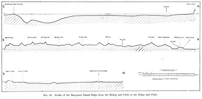
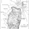
Until the AAE, there had not been any reasonably accurate map produced of Macquarie Island. Blake, the expedition geologist and cartographer (who was on leave from the Geological Survey Department of Brisbane), spent the greater part of his two years on Macquarie Island mapping whole rugged 170km2 island in great detail.
In keeping with his background as a topographical surveyor, Leslie Blake’s basic task for the 12 months the party was originally expected to be on Macquarie Island was to locate and record major landforms (including coast) and geological features in its 170 square kilometres.
He set about this task with a dedication acknowledged many years later by Mawson, who dedicated the relevant AAE Scientific Report to Blake for his ‘two years of arduous field work’. With help from Harold Hamilton, he trudged the length and breadth of the island, first establishing a survey baseline on the northern plateau and then erecting sighting poles on all the prominent features to enable a complete topographic triangulation. Traversing the island’s beaches and cliffs and steep hillsides, criss-crossing its sodden plateau, he completed the most exacting survey of the island’s coastlines and hills, recording its contours and surface features.
Blake thought initially he would have only a year, so he surveyed the coastline and broader topographical features. In his unexpected second year, he repeated the exercise in much greater detail, plotting contour lines at 200-foot (about 61-metre) intervals for the whole island, and at 50-foot (15.24-metre) intervals for a distance of four miles (6.5km) south from the north end. Blake’s map remained the definitive graphic description of Macquarie Island through most of the 20th century.


